Key Features
- Supports monochromatic, panchromatic, three- and multi-channel multispectral imagery.
- Supports scanned aerial film, matrix and push-broom digital airborne cameras, small- and medium-format metric cameras, close-range imagers, orthophotos, RPC satellites, LiDAR, UAS imagery and synthetic aperture radar.
- Imports third-party softcopy and pre-processed UAS projects, aerotriangulation results and other orientation files for quick setup.
- Full range of manual and automatic image orientation capabilities.
- Digitizes 3D vectors directly into AutoCAD, MicroStation, ArcGIS or Global Mapper using DAT/EM’s Capture interface.
- Robust and easy-to-use interface for maximum productivity.
- Bird’s-eye, close-up, project overview, 3D vector split window and multiple viewports offer a variety of visualization and feedback tools.
- Ability to apply coordinate transformation.
- Unlimited zoom levels, fast pan and automatic loading of adjacent stereo models with DAT/EM SuperImposition of CAD and GIS vectors over the image view.
- DAT/EM Ortho+Mosaic module for easy and precise creation of orthomosaics.
- Terrain Visualizer tool for dynamic, real-time preview of contours while DTM and breakline objects are created and edited.
- Contour Creator™ for creating and writing the finished contours to the CAD file.
- Interface to the DAT/EM-PCI ProPack to allow use of PCI Geomatica GDB data. (Requires PCI license)
- Airfield3D™ standards-compliant airspace obstruction mapping tool.
Point Translator for importing, regridding and converting point data, including LiDAR and other DTM features. - Several licensing levels from Professional to Mobile available.
Three Levels of Summit Evolution
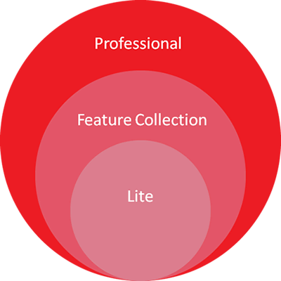
Professional
Full-functional, fully capable digital photogrammetric workstation
more information
Feature Collection
Designed for 3D feature collection for those whose orientation requirements are met elsewhere
more information
Lite
Low-cost system for viewing, terrain following, sample measurement and basic editing in existing projects
more information
Summit Evolution – Feature Comparison
| Professional | Feature Collection | Lite | |
|---|---|---|---|
| Measure & Modify Orientations | |||
| AT Measurement & Export | |||
| Orthophoto & Mosic | |||
| Airfield 3D (ArcGIS only) | |||
| Terrain Visualizer & Contour Creator | |||
| Image Creator | |||
| DAT/EM Drawing Tools | |||
| Project verview | |||
| Edit/contour verification | |||
| MapEditor (AutoCAD & MicroStation) | |||
| 3D Capture for AutoCAD, MicroStation or ArcGIS | |||
| Image management tools | |||
| Super Imposition | |||
| Terrain following | |||
| Import supported softcopy & 3rd party projects | |||
| User documentation & one year technical support | |||
| 3D Stereo viewing | |||
| Landscape Integration |