Software for 3D Data Acquisition
DAT/EM-Systems international
Skyline Soft
PhotoMesh
Combining photos in a wide range of formats, PhotoMesh generates highly-detailed 3D meshes, orthophotos, point clouds, elevation models, and more. PhotoMesh’s breakthrough 2D and 3D mapping technology is based on the highest-performance photogrammetry, computer vision, and computational geometry algorithms.
PhotoMesh employs elaborate tiling mechanisms to efficiently handle projects of any size, even large projects with hundreds of thousands of photos. Running on standard hardware, PhotoMesh can also exploit computer clusters and cloud computing to vastly accelerate the build by running a single project simultaneously on hundreds of fuser machines.
Drone Data to Detailed 3D Models
PhotoMesh Drone converts drone-captured photos, including multi-spectral bands, video, and LiDAR from a variety of sensors into highly-detailed 2D and 3D outputs. Built on high-performance photogrammetry, computer vision, and AI algorithms, PhotoMesh excels at the most challenging mapping and close-range reconstruction projects. PhotoMesh produces outputs in industry-standard formats, including multi-resolution 3D mesh models (3DML, 3D Tiles, SLPK, DAE, OBJ, …), rasters (Orthophoto/True Orthophoto, DSM, DTM), and point clouds (LAS/LAZ), ensuring seamless interoperability with other 2D and 3D GIS solutions.
Optimized Local Hardware Performance
Designed as a powerful, single-computer solution, PhotoMesh Drone fully utilizes local hardware capabilities to deliver fast and accurate photogrammetry and 3D modeling for your projects.
TerraExplorer
A cutting-edge 3D GIS desktop viewer and creator that provides powerful tools and a high resolution 3D environment in which to view, query, analyze and present geospatial data. With TerraExplorer’s robust and extensive capabilities and ever-increasing interoperability, stunningly realistic 3D visualizations can be created by overlaying the terrain with unlimited data layers, 3D models, virtual objects and more.
Datenintegration und Visualisierung
Overlay terrain with imagery and elevation, 3D mesh, BIM, CAD, Lidar point cloud, and feature (vector) layers, and your own custom data. TerraExplorer enables you to create a breathtaking, digital twin that can be used to optimize asset management and tracking.
Leistungsstarke Analysewerkzeuge
Powerful measurement, terrain analysis, line of sight, change detection/comparison and spatial analysis tools make it easy to extract vital intelligence from your geospatial data. This drives smarter decisions in mission planning, urban planning, inspection, and more…
Datenfusion und Performance
TerraExplorer seamlessly fuses terrain, feature layers, raster layers, 3D urban models, point cloud models and 2D and 3D objects into a high-resolution 3D world environment. TerraExplorer employs various mechanisms to ensure high performance even in model-rich projects. Advanced tools allow conversion of 2D and 3D model files from various formats to a stream-optimized Skyline-proprietary format for improved display performance as well as download rate.
3D-Modelle und Inspektion
View and inspect your PhotoMesh 3D models (tower, bridge, construction site, etc.) from within TerraExplorer, together with the source photos used to produce them. You can also create inspection feature layers in which you mark and measure areas (e.g., that require retouching) in your 3D model or on photos in the Photo Inspector.
The Wingtra Drone
Drone – Accessories – Software – Licenses
Optimize your Wingtra drone with the right accessories. Whether sensors, software, or additional equipment – we have the perfect solution for your needs. Explore our range and let us advise you!

Hardware for 3D Software Solutions

3D monitor PluraView
The 3D PluraView beamsplitter technology delivers full monitor resolution up to 4K/UHD at 10-bit in brilliant brightness, thanks to one display per eye. This enables users to work comfortably and without fatigue in all 3D stereo applications.
Highlights
Flicker-free for relaxed 3D work in continuous professional use
Maximum brightness – suitable for normal daylight office environments, with one monitor per stereo channel and per eye
Wide and unrestricted viewing angle – allows group meetings with up to 5 people
Highest resolution – up to 4K (UHD) with 8.3 megapixels per eye at 10-bit color depth
Certified for several hundred applications (PDF list at www.3D-Pluraview.com)
Engineering and manufacturing to the highest quality standards in Germany
Future-proof, established as a plug-and-play technology for more than 17 years
Our best stereo reference: thousands of highly satisfied long-term users

SpaceMouse® Wireless
The SpaceMouse Wireless was designed for use in 3D applications and provides efficient navigation, modeling, and design of complex models. It is ideal for engineers, architects, and 3D designers who require precise control and flexible use. With the SpaceMouse Wireless, creative solutions can be developed and impressive presentations created—whether at the desk, in meeting rooms, or on the go. The wireless connection ensures high mobility and user-friendliness across various working environments.
Key Features
3D connexion sensor with 6 degrees of freedom (6DoF)
2 programmable buttons
Connectivity
3D connexion 2.4 GHz wireless technology
Bluetooth Low Energy
USB-C cable
Contents of Delivery
SpaceMouse Wireless – Bluetooth Edition
Carrying case
3Dc onnexion Universal Receiver
USB-C cable
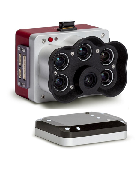
MicaSense RedEdge-P
High-end multispectral camera combining a panchromatic sensor producing high resolution multispectral and RGB images from a single flight.